
Learn
How to Verify Land Using Geospatial Data: A 5-Step Practical Checklist
Combining physical location data with digital land records eliminates real estate scams by ensuring every paper title matches a unique, mathematically verified spot on the Earth's surface. Modern land verification is like upgrading from a static paper map to smartphone navigation, letting buyers view exact, georeferenced digital fence lines overlaid on real-world satellite terrain and legal registries.

| Traditional Paper Surveys | Digital GIS Verification | |
|---|---|---|
| Storage & Durability | Stored in physical filing cabinets; highly prone to wear and tear, environmental damage, and permanent loss of records. | Stored securely on cloud platforms or government digital repositories equipped with edit history tracking and user access logs. |
| Risk of Boundary Overlaps & Double Allocation | High risk; unmapped paper files allow identical plots to be allocated to multiple buyers without immediate detection. | Low risk; GPS-tagged spatial coordinates automatically highlight overlapping boundaries and block duplicate claims. |
| Search & Retrieval Speed | Slow manual searches through disconnected paper files and physical archives, often taking weeks. | Instant, location-based searches using parcel file numbers, owner names, or geographic coordinates. |
| Visual Accuracy | Static 2D hand drawings often lacking strict cartographic standards, elevation context, or physical surroundings. | High-resolution satellite imagery, aerial orthophotos, and drone surveys displaying true real-world ground conditions. |
Understanding these critical differences highlights why traditional paper-based record-keeping systems are inherently vulnerable to error, distortion, and fraud.
1. The Hidden Risks: Why Paper Records Fail Land Buyers Document Tampering and Forgery
Traditional paper land records lack built-in edit tracking, user logs, or automated version control. This absence of digital oversight leaves physical files vulnerable to unauthorized manipulation, forgery, loss, or physical degradation over time.
Misleading Plot Locations & Boundary Disputes
A paper survey plan can look completely flawless on paper while failing to reflect real-world ground conditions. Without spatial verification, a buyer might hold a valid-looking paper document for a plot that actually overlaps with a neighbor's property, extends into a planned road corridor, or sits on reserved state land.
A genuine paper document is useless if it does not match the actual spatial coordinates on the ground.
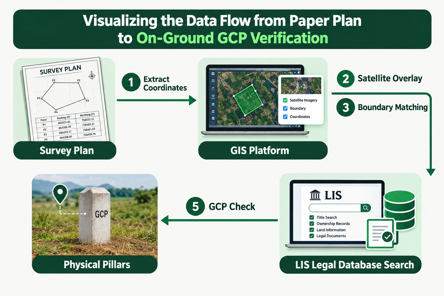
2. The 5-Step Verification Checklist: Step-by-Step Guide
Follow this sequential checklist to verify any land parcel using geospatial technology before committing funds to a real estate transaction.
Step 1: Coordinate Extraction (Reading the Map's GPS Code)
Extract the exact geographic coordinates, such as x/y points, latitude and longitude, or geo-referenced boundary points, listed on the survey plan. Think of this process as reading the land's unique digital address.
Consultant Tip: Never accept a survey plan that lacks coordinate sets tied to the national origin grid. If a plan only shows arbitrary local dimensions without global coordinates, it cannot be spatially verified against government cadastral databases.
Step 2: Satellite Overlay & Ground Analysis
Layer the extracted coordinates over high-resolution satellite imagery, drone surveys, or aerial orthophotos. This step allows you to inspect true physical ground conditions, including existing structures, vegetation cover, soil topography, and surrounding infrastructure from your computer without relying solely on an initial physical site visit.
Step 3: Digital Boundary Matching (Checking for Overlaps) Input the parcel coordinates into a Geographic Information System (GIS) platform to align the property against official cadastral maps. The system automatically draws digital fence lines around the property, instantly flagging whether the plot overlaps with adjacent private properties, public rights-of-way, or unallocated state lands.
Step 4: Centralized LIS Database Search
Query a Land Information System (LIS) database using the spatial plot coordinates or property file number. While GIS provides the "digital map showing the physical house," the LIS acts as the "digital filing cabinet attached to that house," holding crucial legal attribute data including title deeds, owner IDs, survey numbers, zoning regulations, lease terms, and existing tax or mortgage encumbrances.
Consultant Tip: Confirm that the name on the title deed matches and links directly to the spatial parcel ID in the centralized LIS database. A mismatch between spatial boundaries and administrative records is a major legal red flag.
Step 5: On-Ground Pillar Check using GCPs Hire a licensed surveyor to conduct physical field verification using Global Navigation Satellite System (GNSS) surveying technology and electronic Total Stations tied to Ground Control Points (GCPs). GCPs are physical, high-precision reference markers anchored into the earth's surface and calibrated under the regulatory oversight of authority frameworks like the Office of the Surveyor-General of the Federation (OSGOF). These markers ensure physical concrete beacons placed in the ground align perfectly with the digital coordinates recorded in the national cadastral database.
3. Buyer Red Flags Checklist
Watch out for these critical warning signs when conducting land due diligence:
- Coordinate Drift
- Road Corridor & Government Encroachment
- Duplicate File Records
- Unverified Physical Beacons
Check a plot before you pay
Use what you learned here on a real survey plan or title search.